Supported Data Formats
KADAS uses the OGR library to read and write vector data formats, including ESRI shapefiles, MapInfo and MicroStation file formats, AutoCAD DXF, PostGIS, SpatiaLite, Oracle Spatial and MSSQL Spatial databases, and many more. GRASS vector and PostgreSQL support is supplied by native KADAS data provider plugins. Vector data can also be loaded in read mode from zip and gzip archives into KADAS. As of the date of this document, 69 vector formats are supported by the OGR library. The complete list is available at http://www.gdal.org/ogr/ogr_formats.html.
ESRI Shapefiles
The standard vector file format used in KADAS is the ESRI shapefile. Support is provided by the OGR Simple Feature Library (http://www.gdal.org/ogr/).
A shapefile actually consists of several files. The following three are required:
.shpfile containing the feature geometries.dbffile containing the attributes in dBase format.shxindex file
Shapefiles also can include a file with a .prj suffix, which contains the projection information. While it is very useful to have a projection file, it is not mandatory. A shapefile dataset can contain additional files. For further details, see the ESRI technical specification at http://www.esri.com/library/whitepapers/pdfs/shapefile.pdf.
Loading a Shapefile
When loading a vector layer, the following dialog opens:
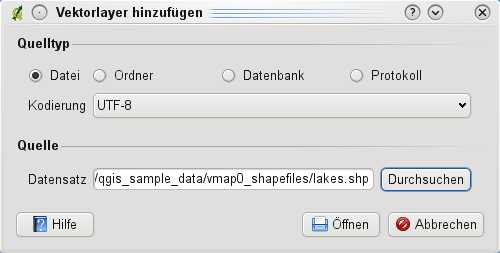
From the available options check  File. Click on [Browse]. That will bring up a standard open file dialog, which allows you to navigate the file system and load a shapefile or other supported data source. The selection box Filter
  allows you to preselect some OGR-supported file formats.
You can also select the encoding for the shapefile if desired.

Selecting a shapefile from the list and clicking [Open] loads it into KADAS.
Layer Colors
When you add a layer to the map, it is assigned a random color. When adding more than one layer at a time, different colors are assigned to each layer.
Once a shapefile is loaded, you can zoom around it using the map navigation tools. To change the style of a layer, open the Layer Properties dialog by double clicking on the layer name or by right-clicking on the name in the legend and choosing Properties from the context menu. See section Style Menu for more information on setting symbology of vector layers.
Improving Performance for Shapefiles
To improve the performance of drawing a shapefile, you can create a spatial index. A spatial index will improve the speed of both zooming and panning. Spatial indexes used by KADAS have a .qix extension.
Use these steps to create the index:
- Open the Layer Properties dialog by double-clicking on the shapefile name in the legend or by right-clicking and choosing Properties from the context menu.
- In the General tab, click the [Create Spatial Index] button.
Problem loading a shape .prj file
If you load a shapefile with a .prj file and KADAS is not able to read the coordinate reference system from that file, you will need to define the proper projection manually within the General tab of the Layer Properties dialog of the layer by clicking the [Specify...] button. This is due to the fact that .prj files often do not provide the complete projection parameters as used in KADAS and listed in the CRS dialog.
For the same reason, if you create a new shapefile with KADAS, two different projection files are created: a .prj file with limited projection parameters, compatible with ESRI software, and a .qpj file, providing the complete parameters of the used CRS. Whenever KADAS finds a .qpj file, it will be used instead of the .prj.